Services
Spatial Mapping
We provide customized services in digital mapping, conversion, and migration and maintenance. We have a wide spectrum of spatial mapping services including:
-
Data conversion and migration
-
Data maintenance
-
Data conflation
-
Data enhancement and cleansing
-
Data quality audit
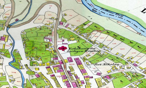
Cadastral Mapping
With emphasis on detailing, we produce sophisticated and informative cadastral maps from hard copies of official land record documents. Our services enable the access of recorded documents via the digital library for decision making and referential purposes. We work on reconstruction of data to enhance topological quality, and offer spatial accuracy. Our cadastral mapping services include:
-
Land records mapping
-
Coordinate Geometry (COGO) mapping
-
Sub-division preparation plan
-
Updating parcel and building number
-
Cadastral / land use / zoning integration
Digital Modeling
Using technologies like Photogrammetry, LiDAR, Remote Sensing / Image Processing and CAD, we offer versatile GIS services to produce high resolution imagery, professional topographic mapping and elaborate 3-D models.
Remote Sensing / Image Processing: Our remote sensing services offer precise images which are invaluable for urban planning, military observation, and in the infrastructure and energy sector. With our niche remote sensing solutions, we help clients plan, develop and execute projects which require spatially distributed information and analysis. We process pertinent data and offer apt solutions to help businesses in strategic decision making.
Our remote sensing services include
-
DEM mosaicing
-
Orthorectification
-
Pansharpening
-
Image mosaicing
-
Color enhancement and tiling
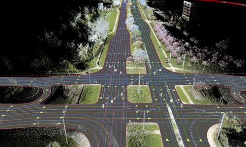
LiDAR: We are at the leading edge of technology in the GIS arena. LiDAR (Light Detection and Ranging) is a remote sensing technology used to create three-dimensional maps of the earth’s surface. LiDAR emits high-frequency light usually from an overhead laser on an aircraft and measures its reflectance with a scanner to produce a geo-referenced location of each point on the earth’s surface in addition to its height. The result is a dense, three-dimensional point cloud of an area that can be used with photogrammetry to produce precise three-dimensional digital elevation and digital terrain models (DEM and DTM).
We offer end-to-end services which help in vectorization and modeling for all kinds of LiDAR data. Our LiDAR Center of Excellence helps optimize efforts and provides the best solutions to our clients.
Our LiDAR services include
-
Agriculture and vegetation mapping
-
Flood mapping and disaster management
-
Power transmission lines classification
-
3D city modeling
-
Contour mapping
-
Bare earth classification
-
Topographic and bathymetric mapping
-
Slope classificationVolumetric calculation
-
Hydrology information
-
Mine site reclamations
-
Digital Terrain Model (DTM), Digital Surface Model (DSM) and Digital Elevation Model (DEM) production
Photogrammetry: With our extensive knowledge and expertise, we offer a plethora of photogrammetric services which are cost effective, accurate, and carefully executed.: Our expert technicians and talented professionals are well-versed in this field ranging from aerial photo processing to developing topographic mapping. Our photogrammetry services include.
-
Aerial photography
-
Aerial triangulation
-
Stereo compilation
-
Contour generation
-
3D vector mapping
-
Digital elevation / terrain modeling
-
Ortho / true ortho photo generation
Web / Enterprise Application Development and Optimization: We have on board top-notch GIS specialists, software engineers and project managers who have rich experience in developing GIS applications. Using the latest software tools, we work meticulously on application design, development, documentation and implementation process.
Our web application development services include
-
Bespoke development
-
Application maintenance and enhancement support
-
Web application development
-
Development and integration of enterprise systems
Mobile / Cloud Apps Development: The current trend shows GIS applications moving into the mobile space, which in turn, is helpful in improving field operations efficiency and making business decisions on time. With the help of mobile apps, it is easier to navigate maps, collate and process data, and utilize tools effectively.
Our mobile / cloud apps development services include
-
Mobile application road map
-
Application and UI conceptualization
-
Multiplatform applications